
Take a look at this blog, and what you will find are high altitude adventures. Since I was a kid, hills have been the focus of my attention, with the open air of giddying heights always captivating me.
Runs not measured in kilometres or miles, but in metres or feet.
I remember at the end of many walks in the hills coming down to the chip shop in Tyndrum and watching a group of hobbling walkers tottering their way into town, laden with enormous rucksacks featuring tents and roll mats bursting from their compartments. In classic Scottish fashion, it would likely be raining or they would be under siege from midges.
“Ouch”, one of us would say. “Some poor sods on the West Highland Way.”
I had done parts of the West Highland Way over the years, as either a short run or a link between the start and end of a hillwalk. I knew of the race for years, but that was for ultra runners – trail runners, even. Yikes!
Somehow, though, I met a girl from the Netherlands who likes doing long-distance running over lots of different terrain, and I started looking behind the crushed contour lines on the map and instead peering at the twisting paths and trails that snake around them.
I couldn’t help being reminded, too, of Nan Shepherd’s maxim that a summit is not the only way to experience a mountain. Sometimes going round, through and beneath them is just as powerful an experience.
And so it was I suggested to Bo a three-and-a-bit-day holiday running the West Highland Way, the 150km trail from Milngavie (Mill-guy) to Fort William.
Before the run
We decided we wanted to go light on this trip, opting to spend a little extra on hostels, bunkhouses or B&Bs instead of carrying camping kit. Despite being a fell-runner, I wasn’t quite used to the ‘travelling light’ that comes with multi-day running.
Bo laughed at my meek question: “So, how many socks are you taking?” “Two. One for running, one for the evening.”
Right. I will take out my extra pair then. In the end, I took slightly more than some would if keeping it minimal, taking two long sleeves as I would likely wear one running most days.
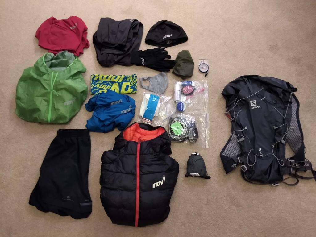
I posted my kit photo the night before and proceeded to not think on it again. The next day, however, I checked my phone and nearly choked on my cheese and ham toastie in Balmaha. The thing had nearly 100 likes with a few amusing queries:
“Not nearly enough midge nets or spray”
“How can I keep track of you?”
“No food?”
In an age where dot-watching and FKTs (records) are every fell and ultra runners equivalent to a football derby, I found it interesting this post blew up in the way it did, with some appearing to believe I was off to break Rob Sinclair’s ridiculously fast record for the Way (13:41.08), which I obviously was not.
For the rest curious as to where the midge nets and food are, I can assure you I took them! For a full list of all my gear, head to the bottom of the page (not including food).
I completed the Lairig Ghru marathon a couple of years ago, which was the last time I ran 42km on trails (the Abraham’s Tea Round obviously being more, but for some reason that was easier!). Since then, though having not ran the distance, I have done a number of days of 6+ hours, so that did not bother me much.
What did make me nervous was, ironically, the terrain. The Lairig Ghru butchered my feet. My Inov-8 Roclite 290s forged a blister the size of my big toe in my arch. Naturally, I decided to rigorously test the shoes I would wear on the West Highland Way to ensure they did not rub…
…by running 10km total in them before leaving. Despite that, I was quietly confident Inov-8’s new TerraUltra G270 would see me through, and that a more leisurely approach to the challenge would prevent too much difficulty.
Still, I felt trepidation. Flatter than any run I would normally do, I was interested to see how I would get on with the repetitive motions of a rolling trail.
Day 1 – Milngavie to Rowardennan
Distance – 43.2km // Elevation – 951m
We hopped off the train at Glasgow Queen Street, changing to the lower line out to Milngavie. The weather could only be described as “driech”, but we felt confident in the promising forecast for the following days.
It was strange knowing that, from here on, we had only the kit on our backs and the shoes on our feet for the next few days. As we took off our masks on a rain-soaked platform, we followed the signs for ‘West Highland Way’.
We passed two women who had just finished their walk who, when asked how it had been, replied with a cagey: “Yeah. Yeah, it was good.”
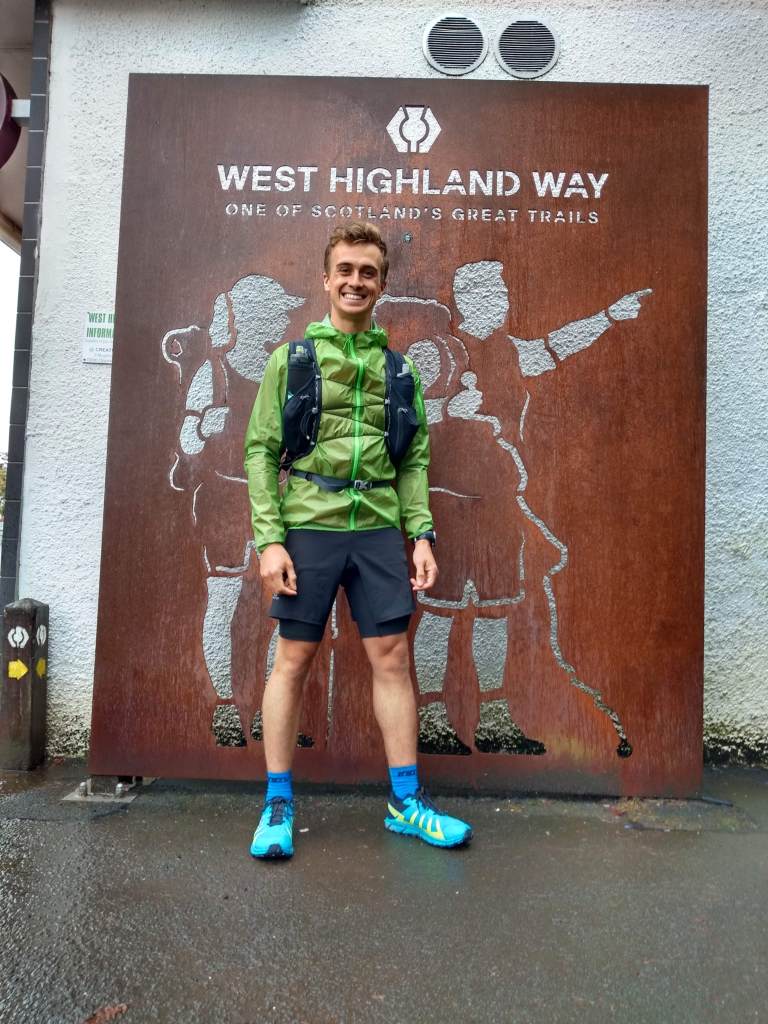
It was quite strange walking to the archway to start the run. Having spent some time in Glasgow, where the West Highland Way was our go-to trail, here we were actually running the thing.
After a few quick photographs, press of the watch button and a joking sprint start, we were off. Off for a big adventure.
Trotting through Mugdock Park, we encountered a number of giant levitating packs which – as we came closer – we found to have people actually carrying them, so hidden were they under a mountain of luggage. I couldn’t help but be grateful for our lighter bags.
Passing below a mist-cloaked Dumgoyne after 9km, we came across our first West Highland Way quirky support board: A mad wee Scots poem outside a tiny ponies enclosure encouraging walkers into the Beech Tree Inn.
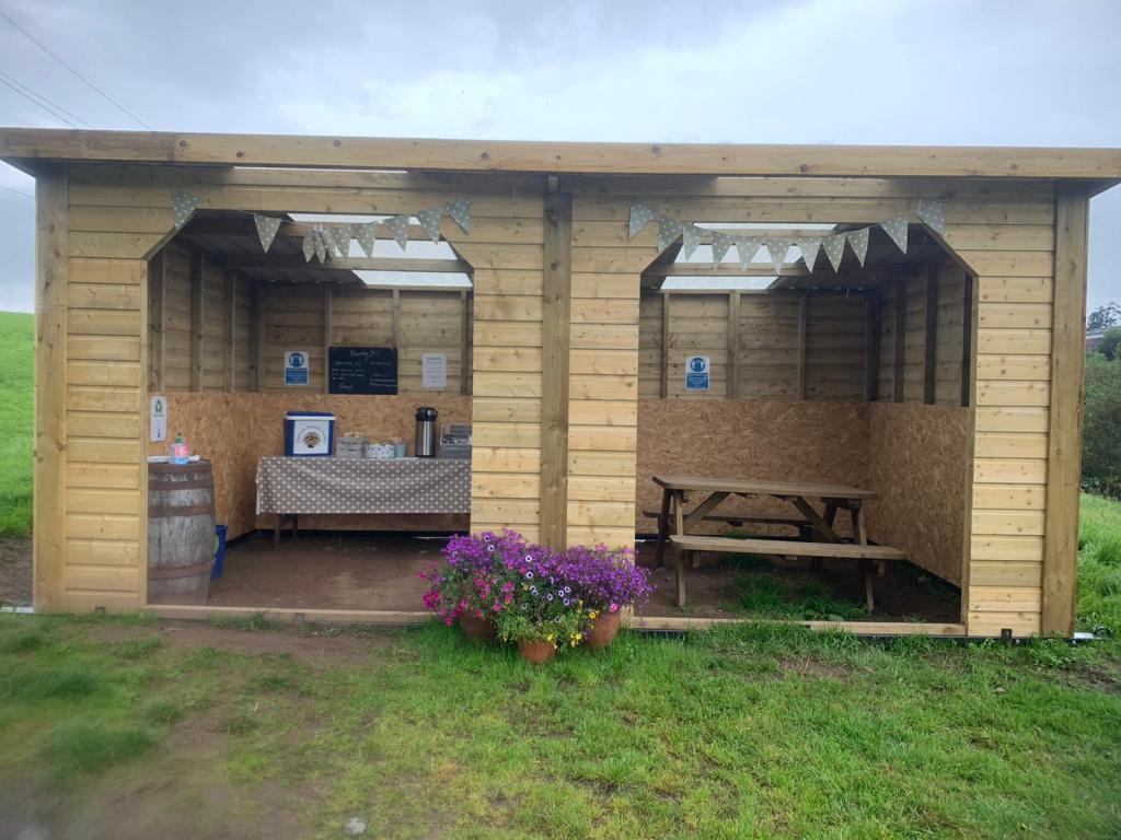
As our day went on, we passed more honesty boxes, pop-up cafes, fun message boards and artwork all encouraging Wayers (for want of a better word) to pop in for a brew or a snack. Some were fairly substantial, like one outside Drymen which featured a wooden shelter, tea kettle, cool box, snacks and a picnic bench!
What was clear was that here was a trail that pulled people and communities together in many ways, and that the infrastructure around this one trail was a sign of how community, tourism and infrastructure come together.
The aim on this adventure was to just keep the food coming. I’ve been trying to be more conscious of the plastic packaging of my bars, so had a stash of Outdoor Provisions bars with me, along with the usual array of flapjacks and malt loaf.
We’d set ourselves up to stop in Drymen for lunch. In the back of my mind, I knew most people stopped there, so had the expectation that the route passes through the town. Following the signs to the right, we carried on through a beautiful hedged path before popping out on the road.
Soon I turned to Bo and said: “I think we’ve missed the town. Do you want to turn around?” We mused for a moment and decided it felt weird to turn back on ourselves now.
Within an hour or so, we were wondering if that had been the right decision! The push from Drymen to Balmaha isn’t easy and, as we climbed through the forest to the iconic Conic Hill, we were missing the taste of a good sandwich and a coffee.
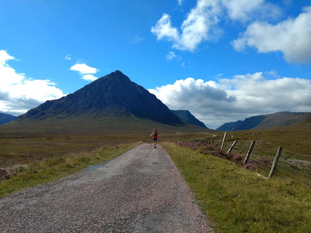
Conic Hill is built up as this ominous trickster of a climb, catching out the unwary traveller. As fell runners, we took it with a pinch of salt. However, after a nice flat stretch above the tree line, I looked left and thought: ‘Crap. We go up there!?’ For some reason, the back of Conic Hill looked more like Ben Lomond with its hood of cloud upon its head.
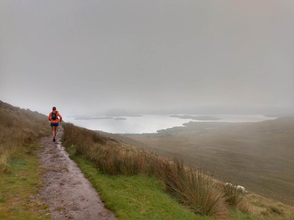
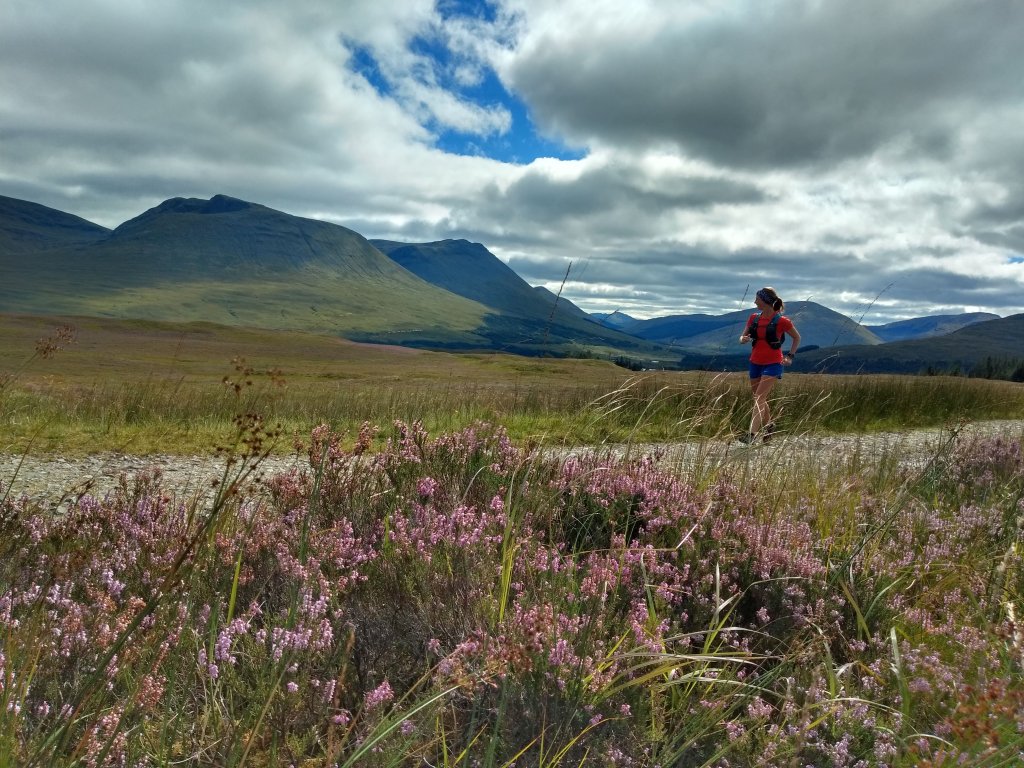
We kept the intensity low, taking time to admire the sea of purple heather upon the hillsides to the north. The Way skirts beneath the 361m summit of Conic Hill, but this meant we could keep just below the cloud to peek out towards the body of Loch Lomond that lay below, peppered with its many islands.
As we descended, it became clear to me why Mountain Rescue is so often called here. Dozens of people were slogging up the heavily eroded path, most in leisurewear, with one group of guys passing us saying, “F**k me, man! A’m swea’in’!” as if it was a novel concept.
It’s great to see them all up there, but with the numbers, the erosion causes greater hazards, with twisted ankles and falls not uncommon as people descend on protesting legs.
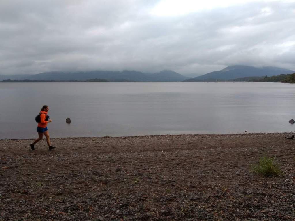
Eventually, after a long 30km push, we made it to Balmaha and the St Mocha Coffee House and Ice-cream Parlour. As is typical for British tourists, the ice-cream was going out the door at a similar rate as the coffee despite the now-pouring rain.
We plonked ourselves into a warm corner of the cafe and devoured a cheese and ham sandwich as the rain came down heavier outside. Hilariously, the ceiling of the cafe has two fake skylights featuring blue skies and sunshine. After some time lost in space, I caught sight of these and snapped my neck as I turned to look outside, only to see droplets bouncing off the pavements.
Slowly regaining our strength, I downed my last cup of tea and we headed out into the rain. We only had to be in the deluge for a short time as we entered the trees to take us to Rowardennan.
People always talk about Conic Hill, but no one mentioned the innumerable 10m steep pitches that riddle the path to Rowardennan. Up, down, up, down – the 10km to the end of the day never seemed to end! Yet, it is a beautiful run for dinner – the idea I was chasing down my tea was a definite motivator.
Soon, Ben Lomond sprouted from between the trees and we made the final few miles to the Rowardennan Hotel. We’d be staying just up the road at the Rowardennan Hostel, but – ask yourself – what’s most important here: Getting showered or eating food?
The Clansman Bar was very quiet, with only a few similarly drenched travellers drying shoes by the fire. We hopped on the recovery train with a steak pie and a burger, eventually hauling ourselves from our chairs to hobble to the hostel.
Set on the shore of Loch Lomond, Rowardennan Lodge is a grand building. Due to Covid-19, we had a room of four to ourselves, with a private washroom – result! We washed our clothes in the sink, ate a flapjack for dessert and hit the sack.
Multi-day running level-up.
Day 2 – Rowardennan to Tyndrum
Distance – 42km // Elevation – 1125m
We left the Rowardennan Hostel on a sunny morning, the ripples of Loch Lomond winking at us with a fresh northerly breeze.
Shaking loose our stiff legs, we headed off towards Inversnaid. Thankfully, the chill wind kept the midges at bay, though every so often we would pass some poor souls packing up tents whilst under siege from the winged teeth. We thanked them for their sacrifice and quickly shot by.
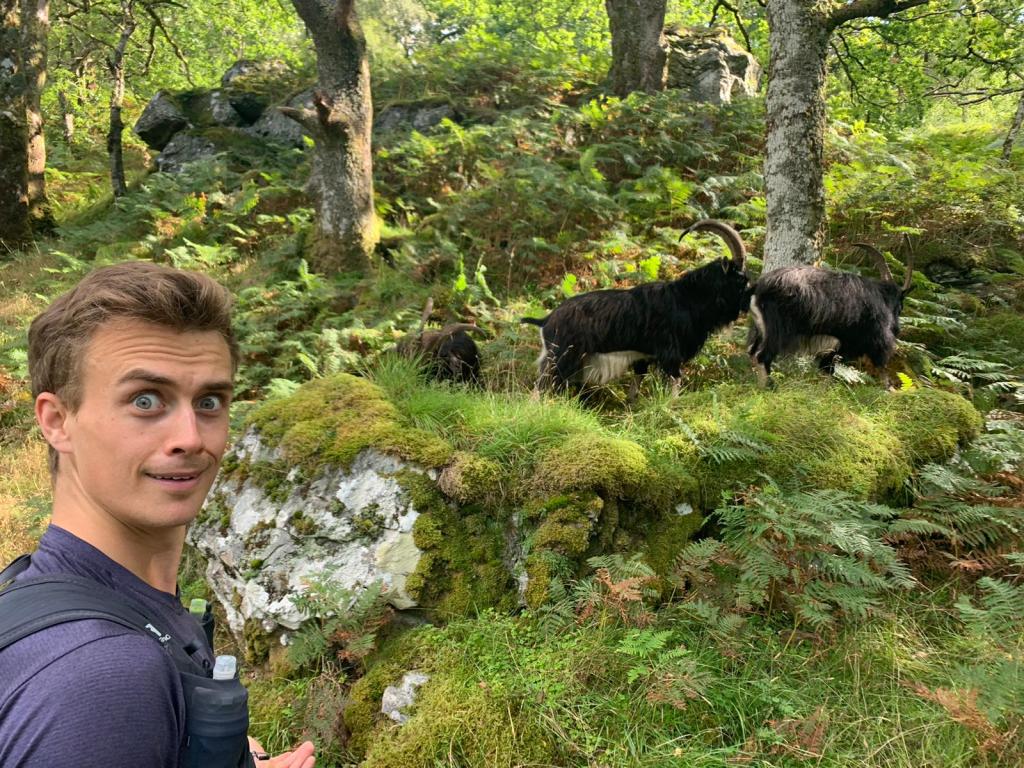
The WalkHighlands website mentions one might see goats after Inversnaid and, lo and behold, as if on cue, they appeared! Huge wild goats, with a smell that followed them over 500m beyond!
Due to the stories I had heard of the ‘rough’ section between Inversnaid and Inverannan, I had in my head some epic boulder field. Despite there being no boulder field, the roots and narrow single-track can make for some slow going. I cannot imagine what it would be like with a 50L rucksack!
By the time we left Inverannan, we were a bit pooped. We knew this would be the long day, with no opportunity for a mid-run coffee stop. Yikes! Aches and pains presented themselves in strange manner, but once we reached the wide gravel track above the A82 to Tyndrum, those began to subside.
It was an incredible thing to look back at this point to Ben Lomond. It looked so very, very far away, and we had done it all on foot. That was quite a feeling.
The path down (which is more down, up, down, up) through the forest transports you to a pine forest in North America. Reaching the Herive Burn, an autumnal sun broke the canopy illuminating millions of glowing spores like fireflies.
By the time we were through the Strathfillan Wigwams, we were pretty goosed, opting to sing along to the soundtrack from Moulin Rouge to gee us up!
Eventually, with shuffling feet, we arrived in Tyndrum. As we hobbled to the Real Food Cafe, I looked at a few people sat drinking outside the Tyndrum Inn and watching us go by. I laughed at how my role had reversed from sympathetic onlooker to John Wayne-esque West Highland Wayer.
Day 3 – Tyndrum to Kinlochleven
Distance – 45km // Elevation – 1048m
Here we are. The long day, but also the most runnable, and our first steps into the proper Highlands. Looking at the route profile, it’s amusing to see the flats replaced with climbs as we steadily enter the higher plains.
It was colder now, as we headed straight into the cold northerly wind. Despite having felt very tender the night before, that morning we felt far better than the previous.

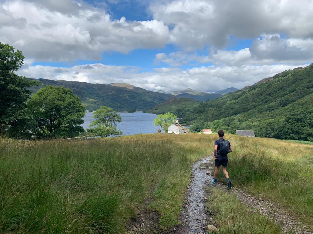
The volcano-like shapes of Beinn Odhar and Beinn Dorain loomed over us as we made short work (well, “short” by my new expectations) of the road to Bridge of Orchy.
As it seemed any other sane Wayer does, we popped into the Orchy Hotel for scones, eventually kicking ourselves out the cosy pub and up the climb to Mam Carraigh. From there, we had a stunning view to my two favourite Munros: Stob Ghabhar and Stob a’Choire Odhar, the car park for which was absolutely rammed when we arrived. Evidence we were now in a Bank Holiday weekend!
Until now, my body had been behaving itself remarkably well. However, as we toddled along Telford’s Parliamentary road to Glencoe, the arch of my left foot began to twinge with pain. Loosening my laces, I marched on, able to largely ignore it under the azure sky as the mountains grew around us like we were in an enormous pop-up picture book.
Telford is best known for his design of the Caledonian Canal, but he was also tasked with the improvement of many old military and drover’s roads in the Highlands during the 19th century. The A82 was now far from us, and we had a wonderful sense of space as we entered Glencoe.
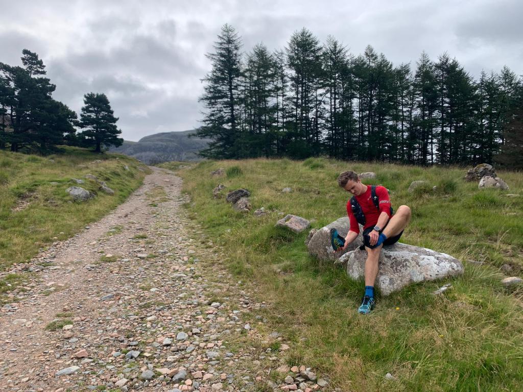
We made a pitstop at King’s House, giving me a chance to remove my shoes and us both to get psyched for the last push to Kinlochleven, aided by a hot chocolate.
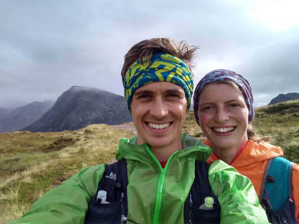
By now it was a truly gorgeous day, Bhuachaille Etive Mor’s famous face was in shadow in a glen flooded with sunlight. However, my foot was not all sunshine and rainbows. I have to thank Bo for letting me almost tear up with the pain and for strapping my foot. I stuck an ibuprofen down me just as we started the ascent of the Devil’s Staircase.
Only in Scotland could you go from Bahamas-like sunshine to rain in 20 minutes. Strangely, as we climbed in the drizzle, the pain in my foot dissipated – maybe it was the painkiller, maybe it had stretched out a bit. Either way, after a speedy ascent of the Staircase (it isn’t as bad as people say) we began trotting down towards Kinlochleven on the long zigzag track, with stunning views over the Mamores.
It was only in the trees where the wind was scarce that we encountered our first midges. They forced us to quicken our pace all the way into town, where we quickly made a beeline to the Getaway Inn.
We drank a shandy and toasted to our final marathon day. All we had now was a cool half marathon and we’d be in Fort William.
Day 3 – Kinlochleven to Fort William
Distance – 25km // Elevation – 632m
The midges swarmed around our heads as we waved goodbye to our B&B hosts and shuffled our way out of Kinlochleven and up the steep climb to the foot of the Mamores. I thought back to that incredible day almost a year ago on the Ring of Steall Skyrace, which took us up on this path on another bright and sunny day.
We left the swarms behind us as we cracked the tree line, jogging through the towering peaks, passing many others on their final day of walking.
My foot wasn’t causing as much issue, but still caused a few frustrated sit downs and another painkiller or two. Eventually, the path turned back on itself and we climbed to a point that gave an excellent view towards Ben Nevis – a sign we were nearly there!
The path lolloped up and down all the way to the forest, before finally nose-diving down towards the road. About two-thirds of the way down, a small brown animal streaked towards us: My mum (not the brown animal) and their dog Meg (the brown animal) were waiting for us, giving a little boost for the final 5k.

Once we left them, our pace picked up a little, and after a few rounds of playing Kokomo obnoxiously loudly on my phone, we hit the road on the final stretch into town. Glen Nevis was packed, with cars perched precariously on verges and pavements – evidence of the strain on rural areas post-lockdown.
We were both quite sore, so we walked the last little uphill into town before making a vow to jog all the way to the finish.
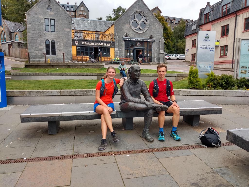
Finally, 150km later, we were jogging up the high street of Fort William. We flopped down on the bench either side of the “Man with sore feet”, eventually getting to our feet and shuffling into the Black Isle Bar.
Some final thoughts…
Running the West Highland Way was something very different for me, and very special. I got to experience a different side of running in Scotland, and a new appreciation for the hills and places I hold so dear.
You will also be amazed by how far your legs can carry you. This trip left me excited for more long distance challenges. Forget about racing, this stuff is just bloody good fun!
Kit list
- Salomon XA 25 pack
- Inov-8 TerraUltra G270
- Inov-8 Race Elite Pro Socks
- Hilly Merino socks
- Salomon Agile Twinskin Shorts
- Ronhill Everyday 5in Shorts
- 2x Runderwear pants
- Inov-8 Trailpant waterproof trousers
- 2x Inov-8 Base Elite L/S tops
- Adidas S/S top
- Inov-8 Ultrashell Pro jacket
- Inov-8 Thermoshell Pro jacket
- Inov-8 All-Terrain gloves
- Inov-8 Train Elite beanie
- Inov-8 wrag/snood/buff
- Suunto Spartan Ultra watch
- 2x soft flasks
- Petzl Reactik headtorch
- Midge hood
- Foil blanket
- Midge spray
- First aid kit
- Toiletries
- Charging cables
- Quick dry towel

Excellent reading and so well written. I love the photos which are stunning. My husband and I are planning the same but ‘other way around’ next June. Is the trail predominantly rocky/path or is it mixed terrain mud/grass/path etc? Also we are doing it early June. Do you think the midges will be bad? Cheers
LikeLike
Hi Lorna. That is great to hear! It’ll be lots of fun! The trail is almost entirely pathed. There are small sections at the end of Loch Lomond that are ‘softer’. Early June, you will get away with it, particularly if you pick a dry week. After that, humidity goes up, and that’s what the midge love! I would still take some repellent, just to be safe!
LikeLiked by 1 person
Cheers for that – great tips 😁
LikeLike
Hi me again 😀. With regards to the backpacks how tall are you both and what sizes did you buy? It’s the 25ml? Can you get a small tent in there or would a 35ml be necessary for that? Thanks 😁
LikeLike
Litre I meant! 😆
LikeLike
Hi Lorna. We are both 5’7″! If you are looking to put a tent in there, I’d suggest 35L. Bo had an 11L, as I had most of the toiletries and shared stuff, but she’s very good with being trim on kit!
LikeLiked by 1 person
Cheers Ross and Bo 😄
LikeLike
Very cool, liked reading this so thank you for posting. Not tried a multi-day run but grew up with multi-day cycling so would love to try it one day!
LikeLike
Surprised that Mountain Rescue is called out to Conic Hill!
LikeLike
A lot, Tom! It’s just the sheer volume of people and the fact it’s small and close to Glasgow, so a lot of people visit who maybe aren’t so well prepared.
LikeLike
Hi Ross,
Just wanted to say thank you so much for this post! I recently completed the West Highland Way solo in 3 days, and your insights were super helpful in preparing for my first multi day running adventure. Thank you!
LikeLike