“If you go near this gully – well, basically, don’t. We won’t see you again.”
“There are trods, but there won’t be anyone mad enough to be up there today.”
“There’s still time to withdraw if your navigation is sub-optimal.”
“Don’t think you can use the ridge as a handrail.”
…
The race organiser’s words drifted across the blank sodden grass as I stood, staring exasperatedly at a wagging compass needle on a damp square of map. It couldn’t be any more obvious where I was to go: a black, scouring line dragged itself across the map, heading from north to south – the Trotternish Ridge. Somehow, it was nowhere to be seen.
The compass needle settled – run!
…
As we stood in the dry sanctuary of the Portree High School, I was close to dismissing that parting comment that we shouldn’t use the ridge as a handrail. How hard could it be, really? The Trotternish Ridge cuts a striking figure on the landscape and if you remember to “not head east, or you’re going to meet a sticky end”, navigation should be a cinch.
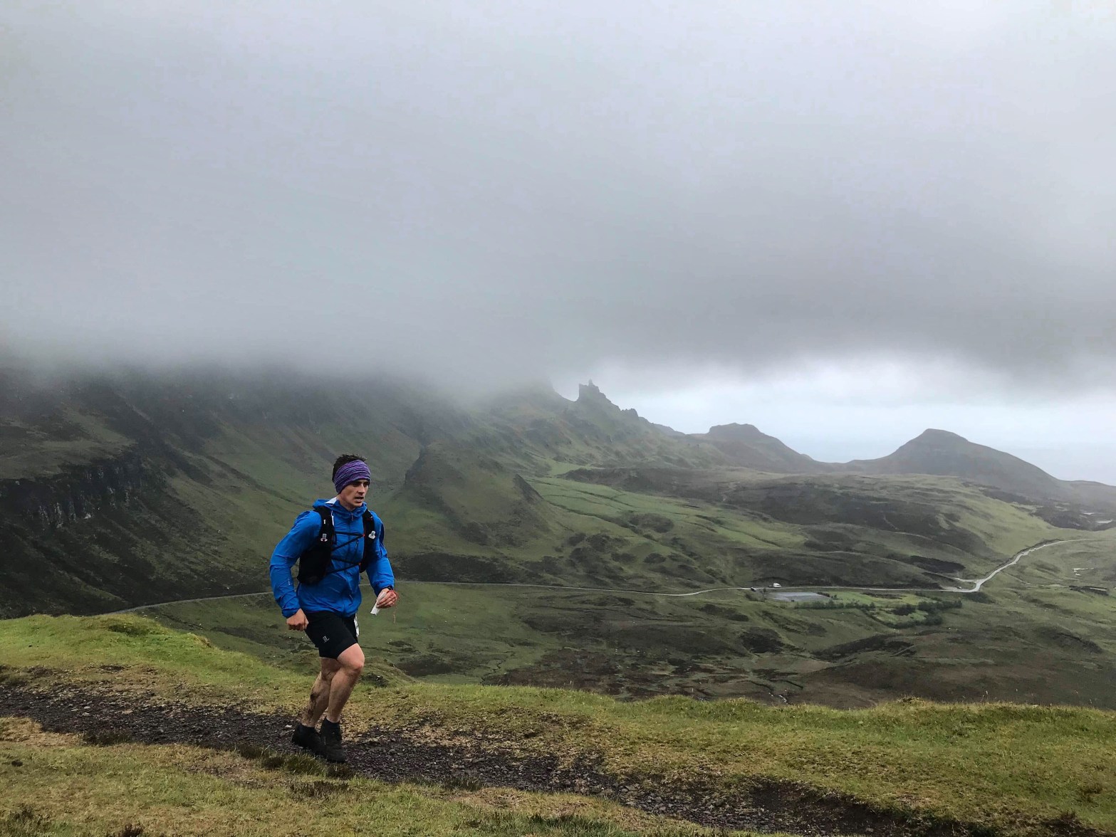
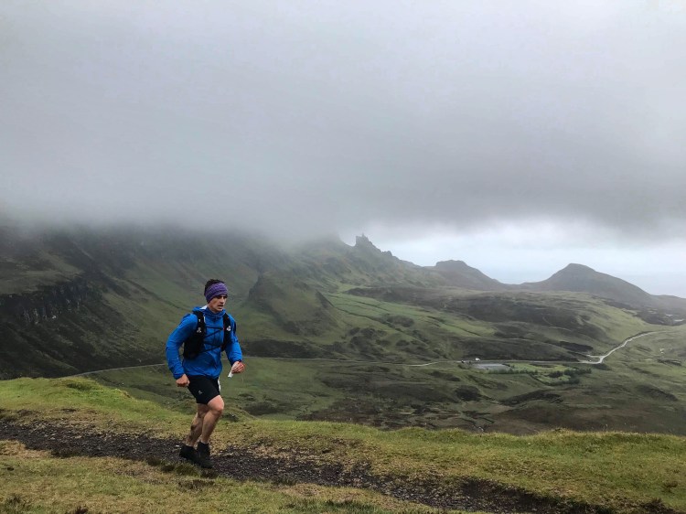
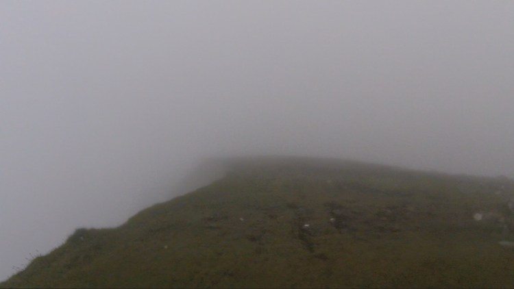
I can categorically say – as I stood at CP1 to take a bearing – it wasn’t. Around us, the squall and clag hang thick. This wasn’t a “veil” of cloud, this was a bucket on your head. I wrote in a previous blog on the Devil’s Burdens Relays that there is a point when running through poor visibility you experience the feeling of falling forwards; the compass needle in your brain loses its magnetism and spins, pointing listlessly in no direction at all. On that square inch on the North Skye map, the “handrail” of the ridge couldn’t be any more elusive, nor the needle in my brain any more wavering.
The Trotternish Ridge is like a natural museum: Often its contents – the Old Man of Storr, the Quiraing – get far more attention than the museum in which they reside. Driving along the meandering road past dozens of tourist groups seeking the sanctuary of lower levels, we peered nervously out and up to the wilderness of the ridge. The Storr leered out of the gloom, waves of cloud washing over the ominous crags surrounding it. The roaring scourge invited us to take to its heights.

Walking off the bus, my number tags lifted and slapped my face in the wind. At each checkpoint, we were to drop a tag into the bright orange box. Behind us, a sweeper would be checking each box for everyone’s number. Interestingly, this wasn’t just a matter of safety or race rules; as the Scottish Natural Heritage manages the ridge, they stipulated where they wanted the race to run in order to protect the rare mosses and high altitude plants. Where they were is a mystery to me, given I could see only as far as my arm would stretch at times.
The weather was far brighter at the start than it would be in, say, 10 minutes. So much so that some people had taken the bold move to take off their jackets. Indeed, one runner – who appeared ethereally out of the pouring rain and cloud much later in the race – kept it off for almost the entire race, taking “skin is pretty waterproof” to a new level entirely.
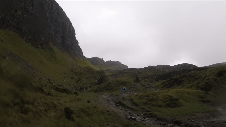
Once out of the starting gates (in classic “three, two, one, go!” hill racing style), we snaked our way around Loch Langaig and Loch Hasco, before taking a sharp right up a scree slope and into an alien landscape. I had mentioned the gloom might add to the general atmosphere of the race, but I had not expected it so early. The landscape was one of wounded giants; large pieces of shrapnel stuck out of the ground; lumps of geological castles lay scattered by the faint path; deep bomb holes filled with freezing water peppered the earth.
About 4km into the race and we were on the ridge, a trail of wandering souls disappearing into the smoke from the battle below. Up there, though, the weather’s war continued. We were soon drenched, a wall of Atlantic air fell upon us – but not the warm type.

The air was so solid I was doubling-up my compass readings with following prints, three of us following the trail like hounds. I stopped for a moment glancing at my compass.
“Look! There!” another called.
I looked up. Like something out of Pirates of the Caribbean, the cloud broke enough for us to spy the car park below us – the shattered rocks of the Quiraing to our left. It was a breathtaking sight. I vividly recall running down the steep hill towards the second checkpoint and thinking, ‘Look left’, and catching a glimpse of this broken volcanic region. It has an almost supernatural quality to it.
I took the time in the car park to grab a drink, knowing it was to be a long 10-plus kilometres until the next checkpoint.
The ridge rose again, our interlude between the clouds brief. I recall one runner being at least 500m ahead of me at CP2, but somehow was behind me halfway towards CP3. It continued like this the entire day: Runners would emerge like zombies from the sea, drifting out of the cloud and joining me on my own journey. Runners would cross your path, fade in and fade out, take a left or right, fall back or surge on – the running peloton swelled and diminished like the movements of a beehive.
My legs felt good. Leaving CP4, a pack of us had reformed, a line of ghosts in what some people call hell but that we call ‘fun’. Several dropped off, four of us pounded on. We descended, trotting through pathless mush.
“Hold up!” one said. Even as he said it, my mental compass was whirring. We had gone wrong.
“We’ve dropped too far”, he repeated, his eyes scanning the terrain. I glanced at my watch. The elevation reading: Ballocks.
In a situation like that, the best thing to do is contour. We stuck to the 400m contour like glue, pulling ourselves below the crags we should have descended next to, hauling our way up rivers and tussocks. A figure faded into the distance – I cannot be sure I actually saw them. Either way, we pursued.
Up another climb we went, before it levelled off and a troop of half a dozen other ghosts charged out towards us and headed to our right, evidently leaving CP5. We found it. Dropping our tags, we went on, our gang of four breaking as the watchful one and I fell in step with one another.
We couldn’t make the same mistake twice…right? Well, we did. Ian (as I learned) and I once again followed a spur too eagerly. Before we knew it, we’d added another 2.5km to this 28km race.
Ian, from Inverness, has done the race three times previously. In sticking with him, I hoped we would find our way back.
I took some bearings, made suggestions. “We’re looking for the green burn”, Ian said sagaciously. “I remember it. Bright green river down a steep slope”. By this point, I was losing the fun factor: I was wet, cold, cramping up – fucking lost.
Well, not lost. I rallied myself: We knew where we had gone wrong and, although no one was near us, people are there to help. Later I learned some had made far bigger errors than us (or had bailed out), dropping off the ridge towards the villages in the west. Someone down there would find a bedraggled runner pounding on their door asking, “Can I use your landline? Also, do you have a bathroom?”
We pounded back up to 500m, found a steep gradient and took it, finding the green burn in the process.
“I remember this: 10 o’clock after the burn”, Ian relayed. After dying down a bit, the wind returned with a vengeance. So did the rain. I hadn’t removed my jacket the entire race, but Ian was exposed. We had both slowed down on the climb, the cold drawing our strength like a Dementor. Everywhere we looked was wet, surrounded by our white prison walls. After battling to put his jacket on, Ian and I followed a set of cairns, knowing the next checkpoint was by one.
As we reached a plateau, there was an odd sense that there was no up or down: The grass was cropped completely level, the ground pan-flat, giving this odd sensation that one was floating. Apparently Storr was next to us, but we never saw it. What I did see, for the first time, were sheep. I knew I was getting delusional when I actually wanted to ask them for directions.
Chucking our tags into CP6, we quickly covered the ground to CP7. After about an hour of seeing nobody else, a meandering soul appeared, hooded and moving well.
“How are you doing, mate?” I asked.
He looked at me grinning: “Yeah! No bad! You?”
“Aye – as good as I can be!” I shouted back.
We marched on. Mercifully, the ridge was now parallel to us, its teeth jutting out of the clag. Our companion dropped off, so Ian and I reached the last two marshals alone. Just as we got to them, though, a perfectly foot-shaped hole appeared below Ian and he dropped right into the thing, instantly cramping up and collapsing.
“I’m alright!” he cried, the marshals moving in to help. “Just cramped.”
He got back on his feet. We dropped into Bealach Beag, the last descent of the race. After 30km of non-stop effort, the shattered rocks of the Bealach Beag were treacherous. Picking our way down, we could see the final couple of kilometres ahead.
We stuck together, reaching the road we had driven along – oh, so very long ago. Marshals clapped as we turned right towards the dam.
Ian groaned, removing his cap to reveal his almost bare head: “I am not looking forward to the drive home after this.”
“You not staying up?” I asked, words not working correctly.
“Nah. Working tonight.”
“What?” I blurted.
“Aye. Firefighter. On the late shift the night”, he said.
I was full of admiration for him.
I recalled, then, seeing Ian just behind me since the start of the race. We had got lost together, found ourselves together and were going to finish together.
The most treacherous part of the whole race, I argue, was the 100m stretch across the dam. That thing was incredibly slippery. I am surprised nobody decked it at the finish line.
Speaking of which: “Where’s the finish?” I asked, looking down the path for a marker.
“That van”, Ian nodded towards the vehicle at the end of the dam.
I laughed. Classic Scottish hill racing.
“Well done”, the organisers said as we crossed the line in 4:26.19.
“How many have finished?” I asked.
“That’s 18 now.”
We staggered. That was less than expected. After all those hiccups, to finish join 17th was nothing to be sniffed at.

Tottering our way back across the lethal dam(n) wall, we opened the door into the hut where there was a mountain of cake, bread, soup and tea. In there were people we had seen on the ridge, some who asked, “Where the hell did you guys go?”; others who said, “I think you win the prize for the furthest distance ran”; but almost all of them shouted: “How good was that!”
After 32km, 2100m, four hours and 26 minutes in the rain and wind – how good was that? Incredible.
Full Strava route.
Scottish Hill Racing results.

3 thoughts on “Skye highs – The Trotternish Ridge Race”